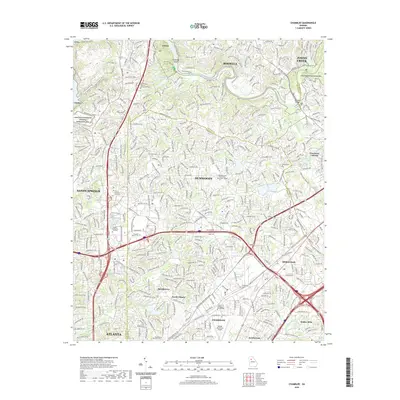
2020 Map of Chamblee
USGS Topo · Published 2020About this map
Chattahoochee River National Recreation Area and the winding Chattahoochee River define the northern corridor of this Atlanta metropolitan landscape. The map captures the dense suburban development of Dunwoody and Sandy Springs during a period of significant growth, where major transit arteries like I-285 and Ga 400 converge. This modern survey provides a detailed look at the institutional footprint of the region, documenting several higher education campuses including Oglethorpe University and Georgia State University Perimeter College.
Find a feature on this map
44 named features on this map. Tap any name to fly to it.
Don’t see what you’re looking for? This feature index may not catch every label — zoom into the map to look around manually.
Map Details
Editions of this 2020 Chamblee Map
This is the sole edition of this map. No revisions or reprints were ever made.
Other maps of this area

1888 · Atlanta
USGS Topo · 1:125,000

1890 · Suwanee
USGS Topo · 1:125,000

1890 · Atlanta
USGS Topo · 1:125,000

1892 · Atlanta
USGS Topo · 1:125,000

1894 · Suwanee
USGS Topo · 1:125,000

1895 · Atlanta
USGS Topo · 1:125,000

1953 · Atlanta
USGS Topo · 1:250,000

1954 · Chamblee
USGS Topo · 1:24,000

1954 · Decatur
USGS Topo · 1:24,000

1954 · Bolton
USGS Topo · 1:24,000