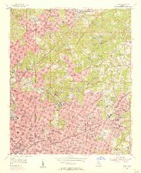
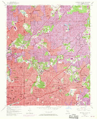
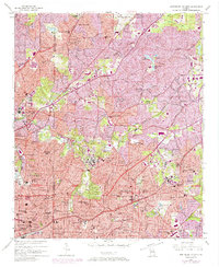
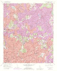
1954 Map of Decatur
USGS Topo · Published 1956About this map
Oglethorpe University and Emory University anchor this mid-century landscape where the eastern expansion of Atlanta meets the established communities of Decatur and Avondale Estates. The map illustrates a period of significant institutional growth, featuring prominent landmarks like Agnes Scott College, the Fernbank Forest and Recreational Center, and the sprawling U S Naval Reservation Atlanta Air Station to the north. Residential patterns are clearly defined by neighborhoods such as Druid Hills, Morningside, and Inman Park, often following the natural drainage of the North Fork Peachtree Creek. This era captures the transition from traditional rail-oriented development along the Georgia Railroad and Southern Railway to the burgeoning automobile age, evidenced by the presence of the Constructors Expressway and major thoroughfares like Peachtree Road. Local centers like Little Five Points and Oakhurst appear as established hubs within the broader suburbanizing terrain of Fulton and DeKalb counties.
Find a feature on this map
93 named features on this map. Tap any name to fly to it.
Don’t see what you’re looking for? This feature index may not catch every label — zoom into the map to look around manually.
Map Details
Editions of this 1954 Decatur Map
4 editions found
Historical Maps of Atlanta Through Time
No other maps found