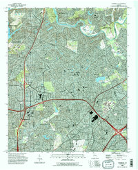
1993 Map of Chamblee
USGS Topo · Published 1995About this map
Oglethorpe University and the sprawling De Kalb-Peachtree Airport anchor the southern portion of this mid-1990s suburban landscape, illustrating the rapid expansion of the northern Atlanta metropolitan area. The map documents a complex transition from historic pathways like the Hightower Trail to the massive infrastructure of the modern era, evidenced by the intricate web of highway interchanges such as Interchange 22 and Interchange 25.
Find a feature on this map
85 named features on this map. Tap any name to fly to it.
Don’t see what you’re looking for? This feature index may not catch every label — zoom into the map to look around manually.
Map Details
Editions of this 1993 Chamblee Map
This is the sole edition of this map. No revisions or reprints were ever made.
Other maps of this area

1888 · Atlanta
USGS Topo · 1:125,000

1890 · Suwanee
USGS Topo · 1:125,000

1890 · Atlanta
USGS Topo · 1:125,000

1892 · Atlanta
USGS Topo · 1:125,000

1894 · Suwanee
USGS Topo · 1:125,000

1895 · Atlanta
USGS Topo · 1:125,000

1953 · Atlanta
USGS Topo · 1:250,000

1954 · Chamblee
USGS Topo · 1:24,000

1954 · Decatur
USGS Topo · 1:24,000

1954 · Bolton
USGS Topo · 1:24,000