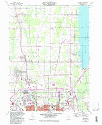
1994 Map of Champion
USGS Topo · Published 1997About this map
The Mahoning River winds through the southwestern corner of this survey, marking a sharp transition from the industrial fringes of Warren to the agricultural townships of the Connecticut Western Reserve. This area, characterized by its historical land lines, features the established community of Champion and several smaller crossroads settlements like Wildare, Klondike, and Morgandale. To the east, the vast expanse of Mosquito Creek Lake and its surrounding Mosquito Creek State Park dominate the landscape, providing a clear boundary for the suburban and rural development in Champion and Bazetta townships.
Find a feature on this map
46 named features on this map. Tap any name to fly to it.
Don’t see what you’re looking for? This feature index may not catch every label — zoom into the map to look around manually.
Map Details
Editions of this 1994 Champion Map
This is the sole edition of this map. No revisions or reprints were ever made.
Other maps of this area

1905 · Bristolville
USGS Topo · 1:62,500

1906 · Youngstown
USGS Topo · 1:62,500

1907 · Kinsman
USGS Topo · 1:62,500

1907 · Bristolville
USGS Topo · 1:62,500

1908 · Youngstown
USGS Topo · 1:62,500

1908 · Warren
USGS Topo · 1:62,500

1950 · Cleveland
USGS Topo · 1:250,000

1952 · West Farmington
USGS Topo · 1:24,000

1952 · Southington
USGS Topo · 1:24,000

1954 · Girard
USGS Topo · 1:24,000