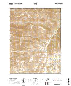
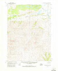
2017 Map of Chandalar A-4 SW
USGS Topo · Published 2017About this map
Trail Creek defines the lower drainage of this interior Alaskan landscape, which was meticulously documented by the U.S. Department of the Interior and the U.S. Geological Survey using data compiled between 2001 and 2017. The terrain is characterized by complex topographic contours that chart the rise and fall of unnamed peaks and ridges, creating a portrait of a wilderness shaped by natural hydrology rather than human settlement. The absence of roads or named outposts highlights the area's isolation within the Yukon-Koyukuk region. This map serves as a precise technical record of the Public Land Survey System divisions, including sections of t27n r7w, t27n r6w, and t26n r6w, which establish the legal framework for this vast, uninhabited reach of the Chandalar country.
Find a feature on this map
7 named features on this map. Tap any name to fly to it.
Don’t see what you’re looking for? This feature index may not catch every label — zoom into the map to look around manually.
Map Details
Editions of this 2017 Chandalar A-4 SW Map
This is the sole edition of this map. No revisions or reprints were ever made.
Other maps of this area

1951 · Chandalar
USGS Topo · 1:250,000

1951 · Beaver
USGS Topo · 1:250,000

1956 · Chandalar
USGS Topo · 1:250,000

1956 · Beaver
USGS Topo · 1:250,000

1964 · Chandalar
USGS Topo · 1:250,000

1964 · Beaver
USGS Topo · 1:250,000
1970 · Beaver D-5
USGS Topo · 1:63,360
1970 · Beaver D-4
USGS Topo · 1:63,360
1970 · Chandalar A-5
USGS Topo · 1:63,360
1970 · Chandalar A-4
USGS Topo · 1:63,360