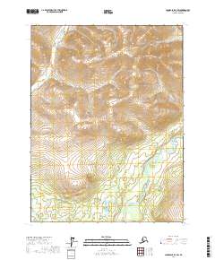
2017 Map of Chandalar B-3 SW
USGS Topo · Published 2017About this map
Middle Fork Chandalar River dominates the southeastern portion of this landscape in the Yukon-Koyukuk region. In this 2017 study, the river's meandering course and braided channels reveal a complex hydrologic pattern beneath high terrain. Siwash Pass provides a significant transit point through the central highlands, marking a break between the ridges that separate the primary watersheds. To the north and east, smaller drainage systems like Big Creek and Agitator Cr carve into the slopes of the Chandalar country. The map clearly delineates the township and range lines, including t29n r4w and t28n r3w, which provide a formal grid over this interior Alaskan wilderness, where the topography rises sharply from the river valley toward the northern peaks.
Find a feature on this map
9 named features on this map. Tap any name to fly to it.
Don’t see what you’re looking for? This feature index may not catch every label — zoom into the map to look around manually.
Map Details
Editions of this 2017 Chandalar B-3 SW Map
This is the sole edition of this map. No revisions or reprints were ever made.
Other maps of this area

1951 · Chandalar
USGS Topo · 1:250,000

1956 · Chandalar
USGS Topo · 1:250,000

1964 · Chandalar
USGS Topo · 1:250,000
1970 · Chandalar A-4
USGS Topo · 1:63,360
1971 · Chandalar B-4
USGS Topo · 1:63,360
1990 · Chandalar B-3
USGS Topo · 1:63,360
1990 · Chandalar A-3
USGS Topo · 1:63,360
2017 · Chandalar A-3 NE
USGS Topo · 1:25,000
2017 · Chandalar A-4 NE
USGS Topo · 1:25,000
2017 · Chandalar A-3 NW
USGS Topo · 1:25,000