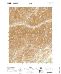
2017 Map of Chandalar B-6 SW
USGS Topo · Published 2017About this map
Coldfoot serves as the primary focal point of this Brooks Range interior landscape, situated along the western edge of a region defined by high-elevation ridges and drainage basins. The area is characterized by a series of significant watercourses, including the westward-flowing Marion Cr and Myrtle Cr, which carve through the steep terrain between townships t29n r11w and t29n r10w. To the south, Winers Lake sits in a lower-lying basin, providing a distinct contrast to the surrounding peak-and-valley topography. The map illustrates a remote wilderness where human activity is centered on the historic settlement of Coldfoot, with the rest of the quadrangle dominated by the natural hydrology of streams like Howard Cr. This topographic study reveals the intricate drainage patterns essential for navigating this part of the Alaskan interior.
Find a feature on this map
9 named features on this map. Tap any name to fly to it.
Don’t see what you’re looking for? This feature index may not catch every label — zoom into the map to look around manually.
Map Details
Editions of this 2017 Chandalar B-6 SW Map
This is the sole edition of this map. No revisions or reprints were ever made.
Other maps of this area

1951 · Chandalar
USGS Topo · 1:250,000

1951 · Wiseman
USGS Topo · 1:250,000

1956 · Chandalar
USGS Topo · 1:250,000

1956 · Wiseman
USGS Topo · 1:250,000

1964 · Wiseman
USGS Topo · 1:250,000

1964 · Chandalar
USGS Topo · 1:250,000

1970 · Wiseman A-1
USGS Topo · 1:63,360
1970 · Chandalar A-6
USGS Topo · 1:63,360
1971 · Wiseman B-1
USGS Topo · 1:63,360
1971 · Chandalar B-6
USGS Topo · 1:63,360