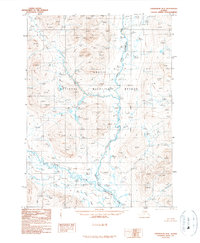
1990 Map of Chandalar D-2
USGS Topo · Published 1990About this map
Arctic National Wildlife Refuge encompasses the entire landscape of this interior Alaskan survey, defined by the winding course of the Middle Fork Chandalar River. The terrain is characterized by periglacial formations, specifically the numerous Pingos identified throughout the river valley and its tributaries. As a provisional study from the late twentieth century, the map documents the hydraulic pattern of Your Creek and the remote Stringo Lakes before significant modern shifts in Arctic hydrology. The presence of the Fairbanks Meridian provides a primary reference for this largely untouched wilderness, where the absence of roads or trails underscores the isolated nature of the Brooks Range foothills. Researchers will find a meticulously charted network of elevations and water bodies that illustrate the complex drainage systems of the subarctic tundra.
Find a feature on this map
6 named features on this map. Tap any name to fly to it.
Don’t see what you’re looking for? This feature index may not catch every label — zoom into the map to look around manually.
Map Details
Editions of this 1990 Chandalar D-2 Map
This is the sole edition of this map. No revisions or reprints were ever made.
Other maps of this area

1951 · Chandalar
USGS Topo · 1:250,000

1951 · Brooks
USGS Topo · 1:250,000

1956 · Chandalar
USGS Topo · 1:250,000

1956 · Philip Smith Mountains
USGS Topo · 1:250,000

1964 · Chandalar
USGS Topo · 1:250,000

1964 · Philip Smith Mountains
USGS Topo · 1:250,000
1971 · Philip Smith Mountains A-2
USGS Topo · 1:63,360
1971 · Philip Smith Mountains A-1
USGS Topo · 1:63,360

1990 · Chandalar C-2
USGS Topo · 1:63,360
1990 · Chandalar D-1
USGS Topo · 1:63,360