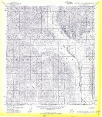
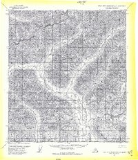
1971 Map of Philip Smith Mountains A-2
USGS Topo · Published 1974About this map
The Middle Fork Chandalar River cuts a prominent path through the high-elevation terrain of the South Boundary Umiat Meridian in this early 1970s survey. This specific sheet was produced as an advance proof and remains nearly devoid of human infrastructure, focusing instead on the complex topography and hydrology of the North Slope. The river valley acts as the primary geographic corridor, winding through steep contour lines that illustrate the elevation changes in the Middle Fork Chandalar River system before more extensive modern mapping was completed. It represents a specific moment in Alaska's surveying history, captured through 1970 aerial photography and preliminary field annotations, highlighting a landscape defined entirely by its natural waterways and land-line divisions.
Find a feature on this map
2 named features on this map. Tap any name to fly to it.
Don’t see what you’re looking for? This feature index may not catch every label — zoom into the map to look around manually.
Map Details
Editions of this 1971 Philip Smith Mountains A-2 Map
2 editions found
Other maps of this area

1951 · Chandalar
USGS Topo · 1:250,000

1951 · Brooks
USGS Topo · 1:250,000

1956 · Chandalar
USGS Topo · 1:250,000

1956 · Philip Smith Mountains
USGS Topo · 1:250,000

1964 · Chandalar
USGS Topo · 1:250,000

1964 · Philip Smith Mountains
USGS Topo · 1:250,000
1971 · Philip Smith Mountains B-1
USGS Topo · 1:63,360
1971 · Philip Smith Mountains A-1
USGS Topo · 1:63,360

1971 · Philip Smith Mountains B-3
USGS Topo · 1:63,360
1971 · Philip Smith Mountains A-3
USGS Topo · 1:63,360