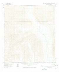
1971 Map of Philip Smith Mountains A-2
USGS Topo · Published 1975About this map
The Middle Fork Chandalar River dominates the eastern drainage of this high-latitude terrain within the Philip Smith Mountains. Surveyed via photogrammetric methods in the early 1970s, the map reveals a landscape defined by sharp elevation shifts and glacial drainages rather than human settlement. The southern portion of the sheet is marked by the Umiat Meridian and a formal Borough Boundary, indicating the administrative divisions of the North Slope. These land lines represent unsurveyed and unmarked locations, as the area remained largely inaccessible and devoid of established roads or permanent structures at the time of the field annotation.
Find a feature on this map
3 named features on this map. Tap any name to fly to it.
Don’t see what you’re looking for? This feature index may not catch every label — zoom into the map to look around manually.
Map Details
Editions of this 1971 Philip Smith Mountains A-2 Map
2 editions found
Other maps of this area

1951 · Chandalar
USGS Topo · 1:250,000

1951 · Brooks
USGS Topo · 1:250,000

1956 · Chandalar
USGS Topo · 1:250,000

1956 · Philip Smith Mountains
USGS Topo · 1:250,000

1964 · Chandalar
USGS Topo · 1:250,000

1964 · Philip Smith Mountains
USGS Topo · 1:250,000
1971 · Philip Smith Mountains B-1
USGS Topo · 1:63,360
1971 · Philip Smith Mountains A-2
USGS Topo · 1:63,360
1971 · Philip Smith Mountains A-1
USGS Topo · 1:63,360

1971 · Philip Smith Mountains B-3
USGS Topo · 1:63,360