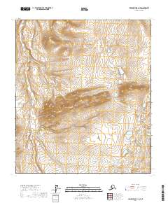
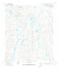
2017 Map of Chandler Lake C-1 SE
USGS Topo · Published 2017About this map
The northern reaches of the North Slope are defined by the high-elevation drainage patterns of May Cr in this 2017 survey. The landscape is characterized by a dense network of contour lines that reveal a complex system of ridges and valleys, illustrating the hydrological divide between various township sections including t9s r8e, t10s r8e, and t11s r8e. This map provides a technical look at the landform relief in a part of Alaska where named features are sparse, focusing on the natural topography rather than human settlement. The absence of roads or established infrastructure highlights the untouched character of the terrain, making it a critical reference for understanding the physical geography of the region as it was documented in the early 21st century.
Find a feature on this map
7 named features on this map. Tap any name to fly to it.
Don’t see what you’re looking for? This feature index may not catch every label — zoom into the map to look around manually.
Map Details
Editions of this 2017 Chandler Lake C-1 SE Map
This is the sole edition of this map. No revisions or reprints were ever made.
Other maps of this area

1951 · Chandler Lake
USGS Topo · 1:250,000

1951 · Brooks
USGS Topo · 1:250,000

1956 · Philip Smith Mountains
USGS Topo · 1:250,000

1956 · Chandler Lake
USGS Topo · 1:250,000

1964 · Philip Smith Mountains
USGS Topo · 1:250,000

1964 · Chandler Lake
USGS Topo · 1:250,000
1971 · Chandler Lake C-1
USGS Topo · 1:63,360
1971 · Philip Smith Mountains B-5
USGS Topo · 1:63,360
1971 · Chandler Lake B-1
USGS Topo · 1:63,360
1971 · Philip Smith Mountains C-5
USGS Topo · 1:63,360