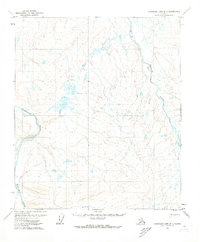
1971 Map of Chandler Lake D-1
USGS Topo · Published 1973About this map
Itkillik River and the Nanushuk River dominate this 1970s topographic landscape in the North Slope region. The drainage patterns of these major water systems reveal the complex topography of the Chandler Lake D-1 area, where numerous unnamed ponds and small lakes dot the tundra between the river valleys. A lone Winter Trail provides the only labeled human navigation route through the western portion of the quadrangle, illustrating the seasonal nature of travel across this Arctic terrain before more permanent infrastructure reached this corner of the state. These survey details, captured through photogrammetric methods by the Geological Survey and field annotated in 1971, document a largely roadless wilderness defined by its natural hydrology.
Find a feature on this map
3 named features on this map. Tap any name to fly to it.
Don’t see what you’re looking for? This feature index may not catch every label — zoom into the map to look around manually.
Map Details
Editions of this 1971 Chandler Lake D-1 Map
This is the sole edition of this map. No revisions or reprints were ever made.
Other maps of this area

1951 · Sagavanirktok D-5
USGS Topo · 1:250,000

1951 · Chandler Lake
USGS Topo · 1:250,000

1951 · Brooks
USGS Topo · 1:250,000

1952 · Umiat
USGS Topo · 1:250,000

1956 · Philip Smith Mountains
USGS Topo · 1:250,000

1956 · Chandler Lake
USGS Topo · 1:250,000

1956 · Sagavanirktok
USGS Topo · 1:250,000

1956 · Umiat
USGS Topo · 1:250,000

1958 · Sagavanirktok
USGS Topo · 1:250,000

1964 · Philip Smith Mountains
USGS Topo · 1:250,000