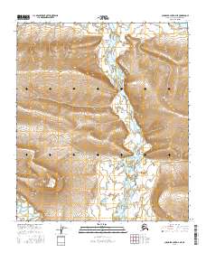
2016 Map of Chandler Lake D-4 NE
USGS Topo · Published 2016About this map
Ninggolik Valley serves as a primary corridor for the Chandler River, which flows through this high-latitude terrain of the North Slope. The landscape is defined by the significant elevation changes between the river valley and prominent geological formations like Ayiyak Mesa. This 2016 survey, produced by the U.S. Geological Survey in cooperation with agencies like the BLM and FWS National Wetlands Inventory, illustrates the complex drainage patterns of the region. The Ayiyak River carves through the southern portion of the quadrangle, highlighting the water-dependent geography that dictates movement across this roadless expanse. Topographic detail captures the intricate contouring of the slopes and the transition from riverbeds to elevated plateaus, providing a precise record of the remote Alaskan interior.
Find a feature on this map
8 named features on this map. Tap any name to fly to it.
Don’t see what you’re looking for? This feature index may not catch every label — zoom into the map to look around manually.
Map Details
Editions of this 2016 Chandler Lake D-4 NE Map
This is the sole edition of this map. No revisions or reprints were ever made.
Other maps of this area

1951 · Chandler Lake
USGS Topo · 1:250,000

1952 · Umiat
USGS Topo · 1:250,000

1955 · Umiat A-4
USGS Topo · 1:63,360

1955 · Umiat A-3
USGS Topo · 1:63,360

1956 · Chandler Lake
USGS Topo · 1:250,000

1956 · Umiat
USGS Topo · 1:250,000

1964 · Chandler Lake
USGS Topo · 1:250,000

1964 · Umiat
USGS Topo · 1:250,000
1987 · Chandler Lake D-3
USGS Topo · 1:63,360
1987 · Chandler Lake D-4
USGS Topo · 1:63,360