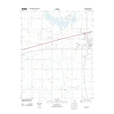
2012 Map of Chandler
USGS Topo · Published 2012About this map
The Deep Fork river system and its various tributaries define the central landscape of this Lincoln County survey, notably where Bell Cow Lake dominates the northern terrain. The city of Chandler serves as the primary hub, showing a dense grid of streets and municipal layout as it appeared in the early 21st century. Genealogists will find this sheet particularly valuable for its high density of rural burial grounds, including Star Valley Cem, Mt Moriah Cem, and several sites clustered near the town center like Oak Park Cem and Clearview Cem. Outside the main settlement, the area retains a distinct section-line road network characteristic of Oklahoma's land runs, punctuated by smaller communities such as Warwick to the west and Midlothian to the south. Local landmarks like Jenny Hill and the recreation areas surrounding Chandler Lake provide additional context for the region's topography.
Find a feature on this map
74 named features on this map. Tap any name to fly to it.
Don’t see what you’re looking for? This feature index may not catch every label — zoom into the map to look around manually.
Map Details
Editions of this 2012 Chandler Map
This is the sole edition of this map. No revisions or reprints were ever made.
Other maps of this area

1905 · Chandler
USGS Topo · 1:62,500

1907 · Chandler
USGS Topo · 1:62,500

1908 · Agra
USGS Topo · 1:62,500

1909 · Luther
USGS Topo · 1:62,500

1909 · Perkins
USGS Topo · 1:62,500

1954 · Oklahoma City
USGS Topo · 1:250,000

1957 · Oklahoma City
USGS Topo · 1:250,000

1963 · Oklahoma City
USGS Topo · 1:250,000
1966 · Luther SE
USGS Topo · 1:24,000
1966 · Wellston
USGS Topo · 1:24,000