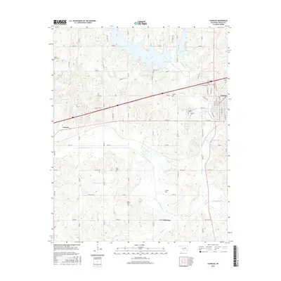
2016 Map of Chandler
USGS Topo · Published 2016About this map
The Deep Fork river meanders through the heart of Lincoln County, defining the drainage patterns of this central Oklahoma landscape. Near the town of Chandler, the terrain transitions from the developed streets of the county seat to the expansive waters of Bell Cow Lake and Chandler Lake. This era shows a complex network of rural section-line roads, such as e0900 RD and n3410 RD, which connect a series of established community centers and historic burial grounds. Genealogists and local historians will find several notable landmarks, including Oak Park Cem, Mount Moriah Cem, and the small settlement of Midlothian. To the west, the community of Warwick sits near the banks of Rat Cr, while higher elevations like Jenny Hill overlook the river valley, illustrating the balance between the region's agricultural roots and its modern water management infrastructure.
Find a feature on this map
68 named features on this map. Tap any name to fly to it.
Don’t see what you’re looking for? This feature index may not catch every label — zoom into the map to look around manually.
Map Details
Editions of this 2016 Chandler Map
This is the sole edition of this map. No revisions or reprints were ever made.
Other maps of this area

1905 · Chandler
USGS Topo · 1:62,500

1907 · Chandler
USGS Topo · 1:62,500

1908 · Agra
USGS Topo · 1:62,500

1909 · Luther
USGS Topo · 1:62,500

1909 · Perkins
USGS Topo · 1:62,500

1954 · Oklahoma City
USGS Topo · 1:250,000

1957 · Oklahoma City
USGS Topo · 1:250,000

1963 · Oklahoma City
USGS Topo · 1:250,000
1966 · Luther SE
USGS Topo · 1:24,000
1966 · Wellston
USGS Topo · 1:24,000