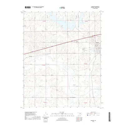
2018 Map of Chandler
USGS Topo · Published 2018About this map
Chandler serves as the focal point of this Lincoln County survey, situated at a major transportation junction where the landscape transitions into the river bottoms. The Deep Fork river meanders through the southern half of the quadrangle, creating a complex network of wetlands and tributaries including Kickapoo Cr and Pecan Cr. For genealogists and local historians, this map is particularly valuable for its dense concentration of burial sites, ranging from the large Oak Park Cem and Clearview Cem near the town center to more isolated locations like Sweet Home Cem and McCorkle Cem. The area's water resources are anchored by Chandler Lake in the north and the 08104 Reservoir, while the small settlements of Warwick and Midlothian mark the rural corridors connecting the county's agricultural and river-bottom lands.
Find a feature on this map
42 named features on this map. Tap any name to fly to it.
Don’t see what you’re looking for? This feature index may not catch every label — zoom into the map to look around manually.
Map Details
Editions of this 2018 Chandler Map
This is the sole edition of this map. No revisions or reprints were ever made.
Other maps of this area

1905 · Chandler
USGS Topo · 1:62,500

1907 · Chandler
USGS Topo · 1:62,500

1908 · Agra
USGS Topo · 1:62,500

1909 · Luther
USGS Topo · 1:62,500

1909 · Perkins
USGS Topo · 1:62,500

1954 · Oklahoma City
USGS Topo · 1:250,000

1957 · Oklahoma City
USGS Topo · 1:250,000

1963 · Oklahoma City
USGS Topo · 1:250,000
1966 · Luther SE
USGS Topo · 1:24,000
1966 · Wellston
USGS Topo · 1:24,000