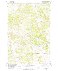
1980 Map of Chandler Spring
USGS Topo · Published 1980About this map
The Musselshell Co Yellowstone Co line runs through this interior landscape, marking a transition across the high plains of central Montana. The terrain is defined by a network of drainage systems including Shed Burnt Coulee and Angus Bell Coulee in the north, while the southern portion is carved by Hawk Creek and East Buffalo Cr. This 1970s-era topography reveals a sparse but industrial footprint of resource extraction, with numerous sites marked simply as Well and specific locations like Well 3360 or a Drill Hole indicating active exploration or production. The most significant natural watering point is Chandler Spring, located near the headwaters of Carpenter Creek. This survey provides a clear view of the ranching and energy infrastructure before the turn of the twenty-first century, showing the scattered network of roads and fence lines that connect these remote water and mineral sources.
Find a feature on this map
12 named features on this map. Tap any name to fly to it.
Don’t see what you’re looking for? This feature index may not catch every label — zoom into the map to look around manually.
Map Details
Editions of this 1980 Chandler Spring Map
This is the sole edition of this map. No revisions or reprints were ever made.
Other maps of this area

1954 · Forsyth
USGS Topo · 1:250,000

1954 · Roundup
USGS Topo · 1:250,000

1957 · Forsyth
USGS Topo · 1:250,000

1958 · Roundup
USGS Topo · 1:250,000

1958 · Forsyth
USGS Topo · 1:250,000

1962 · Queens Point
USGS Topo · 1:24,000

1963 · Melstone
USGS Topo · 1:24,000

1963 · Musselshell
USGS Topo · 1:24,000

1979 · Roundup
USGS Topo · 1:100,000

1979 · Melstone
USGS Topo · 1:100,000