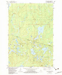
1982 Map of Chaney Lake
USGS Topo · Published 1983About this map
Chaney Lake and a dense network of smaller water bodies dominate this borderland landscape between Michigan and Wisconsin in the early 1980s. The terrain is defined by the legacy of industrial transit, specifically the Old Railroad Grade that cuts through the town of Chaney and the township of Bessemer, reflecting the region's logging and transport history. To the south, the settlement of Winchester is situated near several lakes, including Virgin Lake and Pardee Lake. Local infrastructure is marked by features such as the Trostel Lookout Tower and multiple Gravel Pits, while the Presque Isle River and Little Black River drain the northern reaches of the quadrangle. The map reveals a transition from the structured grids of the Bessemer area to the more labyrinthine lake country of Oma, providing a detailed look at the geographic connectivity across state lines before modern development patterns intensified.
Find a feature on this map
61 named features on this map. Tap any name to fly to it.
Don’t see what you’re looking for? This feature index may not catch every label — zoom into the map to look around manually.
Map Details
Editions of this 1982 Chaney Lake Map
This is the sole edition of this map. No revisions or reprints were ever made.
Other maps of this area

1939 · Winchester
USGS Topo · 1:48,000

1940 · Mercer
USGS Topo · 1:48,000

1943 · Ironwood
USGS Topo · 1:48,000

1945 · Mercer
USGS Topo · 1:48,000

1946 · Winchester
USGS Topo · 1:48,000

1947 · Mercer
USGS Topo · 1:48,000

1953 · Ashland
USGS Topo · 1:250,000

1955 · Mercer
USGS Topo · 1:62,500

1955 · Winchester
USGS Topo · 1:62,500

1955 · Bessemer
USGS Topo · 1:24,000