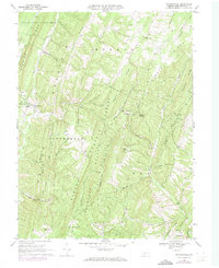
1968 Map of Chaneysville
USGS Topo · Published 1973About this map
Chaneysville and its surrounding valleys are defined by the sharp verticality of the Buchanan Mountain and Ragged Mountain ridges. This 1968 study, updated in 1973, reveals a rural landscape where social and spiritual life centered on a network of small country churches, including Bethel Ch near the town center and Zion Ch to the north. The area's complex drainage is marked by the convergence of Wilson Run and Town Creek, carving deep hollows such as Buttermilk Hollow between the high ridges. The presence of numerous Gas Wells throughout the Monroe and Southampton townships indicates the significance of subterranean resources even in this heavily forested region, much of which is protected within the Buchanan State Forest.
Find a feature on this map
51 named features on this map. Tap any name to fly to it.
Don’t see what you’re looking for? This feature index may not catch every label — zoom into the map to look around manually.
Map Details
Editions of this 1968 Chaneysville Map
4 editions found
Other maps of this area

1898 · Paw Paw
USGS Topo · 1:62,500

1899 · Flintstone
USGS Topo · 1:62,500

1900 · Pawpaw
USGS Topo · 1:62,500

1900 · Flintstone
USGS Topo · 1:62,500

1910 · Paw Paw
USGS Topo · 1:62,500

1927 · Clearville
USGS Topo · 1:48,000

1927 · Hyndman
USGS Topo · 1:62,500

1931 · Clearville
USGS Topo · 1:62,500

1931 · Hyndman
USGS Topo · 1:62,500

1944 · Hyndman
USGS Topo · 1:62,500
Featured Places
- Inglesmith, Mann Township
- Mann Township, PA
- Southampton Township, PA
- Monroe Township, PA
- Chaneysville, Southampton Township