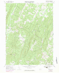
1968 Map of Chaneysville
USGS Topo · Published 1983About this map
Warrior Ridge and Clear Ridge dominate this section of the Pennsylvania-Maryland borderlands, where narrow valleys dictate the path of early settlements and roads. The small village of Chaneysville serves as a central hub for the surrounding ridges, connected to outlying communities like Elbinsville and Millers Corners by winding routes such as Redinger Road and Shaffer Road. This 1960s survey documents a landscape heavily influenced by public lands, including State Game Lands No 97 and the Buchanan State Forest, which preserve the steep timberlands between Ragged Mountain and Buchanan Mountain. Scattered throughout these heights are signs of rural persistence, from several Gas Wells and a Drill Hole to historic congregations at Zion Ch, Bethel Ch, and Lebanon Ch. The intricate drainage network of Sweet Root Creek and Fifteenmile Creek further defines the geography of Southampton and Monroe townships.
Find a feature on this map
54 named features on this map. Tap any name to fly to it.
Don’t see what you’re looking for? This feature index may not catch every label — zoom into the map to look around manually.
Map Details
Editions of this 1968 Chaneysville Map
4 editions found
Other maps of this area

1898 · Paw Paw
USGS Topo · 1:62,500

1899 · Flintstone
USGS Topo · 1:62,500

1900 · Pawpaw
USGS Topo · 1:62,500

1900 · Flintstone
USGS Topo · 1:62,500

1910 · Paw Paw
USGS Topo · 1:62,500

1927 · Clearville
USGS Topo · 1:48,000

1927 · Hyndman
USGS Topo · 1:62,500

1931 · Clearville
USGS Topo · 1:62,500

1931 · Hyndman
USGS Topo · 1:62,500

1944 · Hyndman
USGS Topo · 1:62,500
Featured Places
- Inglesmith, Mann Township
- Mann Township, PA
- Southampton Township, PA
- Monroe Township, PA
- Chaneysville, Southampton Township