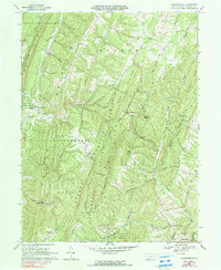
1968 Map of Chaneysville
USGS Topo · Published 1990About this map
Warrior Mountain and Ragged Mountain dominate this section of Bedford County, where the landscape is defined by parallel ridges and steep hollows. The area's settlement pattern follows these natural corridors, with clusters like Chaneysville and Five Forks situated at key gaps and intersections. The map highlights a network of mountain roads and rural community life, documented through numerous country churches such as Bethel Ch and Mt Zion Ch.
Find a feature on this map
44 named features on this map. Tap any name to fly to it.
Don’t see what you’re looking for? This feature index may not catch every label — zoom into the map to look around manually.
Map Details
Editions of this 1968 Chaneysville Map
4 editions found
Other maps of this area

1898 · Paw Paw
USGS Topo · 1:62,500

1899 · Flintstone
USGS Topo · 1:62,500

1900 · Pawpaw
USGS Topo · 1:62,500

1900 · Flintstone
USGS Topo · 1:62,500

1910 · Paw Paw
USGS Topo · 1:62,500

1927 · Clearville
USGS Topo · 1:48,000

1927 · Hyndman
USGS Topo · 1:62,500

1931 · Clearville
USGS Topo · 1:62,500

1931 · Hyndman
USGS Topo · 1:62,500

1944 · Hyndman
USGS Topo · 1:62,500
Featured Places
- Inglesmith, Mann Township
- Mann Township, PA
- Southampton Township, PA
- Monroe Township, PA
- Chaneysville, Southampton Township