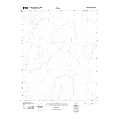
2010 Map of Channing NW
USGS Topo · Published 2010About this map
Rita Blanca Creek and Punta de Agua Creek carve through the high plains of Hartley County, defining the drainage patterns of this Panhandle landscape. The map reveals a region organized around ranching and rural infrastructure, where isolated landmarks like Flats Windmill indicate the vital importance of water management in a semi-arid environment. Transportation is governed by a grid of farm-to-market roads and county routes, including FM 767, FM 2357, and Co RD Y, which connect the scattered homesteads and pastures. In the southeast, Los Redos Creek further illustrates the complex network of intermittent and permanent waterways that shape the local geography. This 2010 survey provides a clear look at the intersection of natural hydrology and the human efforts to settle and work the Texas north country.
Find a feature on this map
7 named features on this map. Tap any name to fly to it.
Don’t see what you’re looking for? This feature index may not catch every label — zoom into the map to look around manually.
Map Details
Editions of this 2010 Channing NW Map
This is the sole edition of this map. No revisions or reprints were ever made.
Other maps of this area

1954 · Tucumcari
USGS Topo · 1:250,000

1958 · Tucumcari
USGS Topo · 1:250,000

1963 · Hartley SE
USGS Topo · 1:24,000

1971 · Proctor Ranch
USGS Topo · 1:24,000

1971 · Channing NW
USGS Topo · 1:24,000

1971 · Many Post Camp
USGS Topo · 1:24,000

1971 · Boys Ranch West
USGS Topo · 1:24,000
1971 · Torrey House
USGS Topo · 1:24,000
1971 · Channing
USGS Topo · 1:24,000

1972 · Hartley SW
USGS Topo · 1:24,000