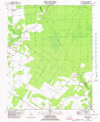
1982 Map of Chapanoke
USGS Topo · Published 1982About this map
The Great Dismal Swamp dominates the northeastern landscape of this map, illustrating the heavy influence of wetlands on the settlement patterns of Perquimans County. Small communities and family landmarks are clustered along the margins of the swamp and the banks of the Perquimans River and Little River. Transportation history is clearly visible through the presence of the Norfolk Southern line passing through Chapanoke and the distinct path of an Old Railroad Grade further north. This 1982 edition, based on earlier surveys, serves as a record of rural life in the Albemarle region, documenting established spiritual and community centers like Up River Ch and Oak Grove Ch. The map provides specific locations for several unmarked burial sites, simply labeled Cem, alongside named plots such as the Up River Cem near the town of Nicanor.
Find a feature on this map
17 named features on this map. Tap any name to fly to it.
Don’t see what you’re looking for? This feature index may not catch every label — zoom into the map to look around manually.
Map Details
Editions of this 1982 Chapanoke Map
This is the sole edition of this map. No revisions or reprints were ever made.
Other maps of this area

1904 · Edenton
USGS Topo · 1:62,500

1906 · Hertford
USGS Topo · 1:62,500

1906 · Beckford
USGS Topo · 1:48,000

1907 · Beckford
USGS Topo · 1:62,500

1940 · Hertford
USGS Topo · 1:62,500

1940 · Beckford
USGS Topo · 1:62,500

1940 · South Mills
USGS Topo · 1:62,500

1942 · Edenton
USGS Topo · 1:62,500

1943 · Edenton
USGS Topo · 1:62,500

1952 · South Mills
USGS Topo · 1:62,500