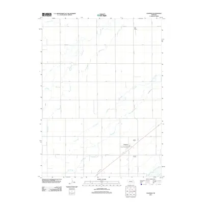
2011 Map of Chapman
USGS Topo · Published 2011About this map
Chapman serves as the focal point of this agricultural landscape in Merrick County, situated where the prairie meets a complex network of waterways. The settlement's infrastructure is clearly defined by the Chapman Post Office and its proximity to the rail line, while local history is anchored by the Chapman Cemetery and the more northerly Prairie Creek Cemetery. The terrain is characterized by a series of roughly parallel watercourses including Prairie Creek, Silver Creek, and Moores Creek, all trending northeast toward the Platte River system. The gridded road network, including Chapman RD and Archer RD, segments the fertile plains between these creeks and sloughs like Warm Slough. Near the southern boundary, the Wood River meanders through the landscape, while Bader Park Rd provides access toward the river bottomlands, reflecting the enduring rural character of this Nebraska community in the early 21st century.
Find a feature on this map
32 named features on this map. Tap any name to fly to it.
Don’t see what you’re looking for? This feature index may not catch every label — zoom into the map to look around manually.
Map Details
Editions of this 2011 Chapman Map
This is the sole edition of this map. No revisions or reprints were ever made.
Other maps of this area

1892 · Grand Island
USGS Topo · 1:62,500

1895 · Grand Island
USGS Topo · 1:62,500

1898 · Grand Island
USGS Topo · 1:125,000

1899 · St. Paul
USGS Topo · 1:125,000

1955 · Broken Bow
USGS Topo · 1:250,000

1955 · Grand Island
USGS Topo · 1:250,000

1956 · Broken Bow
USGS Topo · 1:250,000

1957 · Grand Island
USGS Topo · 1:250,000

1958 · Grand Island
USGS Topo · 1:250,000
1961 · Palmer
USGS Topo · 1:24,000