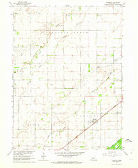
1962 Map of Chapman
USGS Topo · Published 1963About this map
Chapman serves as the central hub of this Merrick County landscape, situated where the Union Pacific railroad cuts a diagonal path through the fertile plains of the Missouri River Basin. The map captures a highly organized agricultural grid, punctuated by vital community institutions like School No. 28, School No. 29, and the Pleasant View Sch. These rural schoolhouses and the Chapman Cem reflect the distributed nature of early Nebraska prairie life. A complex network of watercourses, including the Platte River, Wood River, and the branching Warm Slough, dictates the drainage patterns and land use of the Vieregg area. The presence of a Radio Tower and a Gravel Pit indicates the gradual overlay of mid-century infrastructure and industry onto the established farming territory, while the detailed plotting of fence and field lines provides a high-fidelity view of the 1960s rural layout.
Find a feature on this map
18 named features on this map. Tap any name to fly to it.
Don’t see what you’re looking for? This feature index may not catch every label — zoom into the map to look around manually.
Map Details
Editions of this 1962 Chapman Map
This is the sole edition of this map. No revisions or reprints were ever made.
Other maps of this area

1892 · Grand Island
USGS Topo · 1:62,500

1895 · Grand Island
USGS Topo · 1:62,500

1898 · Grand Island
USGS Topo · 1:125,000

1899 · St. Paul
USGS Topo · 1:125,000

1955 · Broken Bow
USGS Topo · 1:250,000

1955 · Grand Island
USGS Topo · 1:250,000

1956 · Broken Bow
USGS Topo · 1:250,000

1957 · Grand Island
USGS Topo · 1:250,000

1958 · Grand Island
USGS Topo · 1:250,000
1961 · Palmer
USGS Topo · 1:24,000