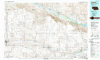
1985 Map of Chappell
USGS Topo · Published 1989About this map
Ash Hollow State Historical Park and the historic Oregon Trail define the corridor of the North Platte River in this 1980s landscape. This survey documents a critical junction of Western migration and rail expansion, where the Union Pacific follows the natural grade of Lodgepole Creek through the settlements of Sidney, Lodgepole, and Chappell. The map captures the varied topography of the High Plains, from the prominent Lookout Mound and Sugar Loaf to the significant recreational and wildlife areas surrounding the western end of Lake Mc Conaughy. Local history and genealogy researchers can find specific landmarks such as the Bluewater Battlefield Overlook Site and various rural oil fields, alongside the distinct draws and basins like Walrath Draw and Devils Washbasin that have long dictated the movement of people and livestock across the Nebraska-Colorado borderlands.
Find a feature on this map
53 named features on this map. Tap any name to fly to it.
Don’t see what you’re looking for? This feature index may not catch every label — zoom into the map to look around manually.
Map Details
Editions of this 1985 Chappell Map
2 editions found
Other maps of this area

1896 · Browns Creek
USGS Topo · 1:125,000

1897 · Ogallala
USGS Topo · 1:125,000

1898 · Camp Clarke
USGS Topo · 1:125,000

1899 · Browns Creek
USGS Topo · 1:125,000

1899 · Sidney
USGS Topo · 1:125,000

1900 · Chappell
USGS Topo · 1:125,000

1900 · Ogallala
USGS Topo · 1:125,000

1949 · Rackett
USGS Topo · 1:62,500

1950 · Velma
USGS Topo · 1:62,500

1950 · Crescent Lake
USGS Topo · 1:62,500