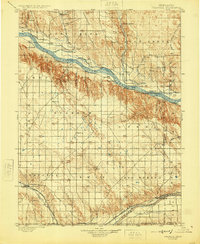
1900 Map of Chappell
USGS Topo · Published 1925About this map
Rachael Pattison's Grave sits as a lonely landmark along the Old California Trail, marking the profound human history etched into this Nebraska landscape at the turn of the century. The region is defined by the dual lifelines of the North Platte River and the South Platte River (Main Channel), where early irrigation efforts are visible through a complex network of hand-drawn waterways like the Spohn Canal, Graf Canal, and Robbins and Williams Canal. These systems supported early agricultural settlements such as Oshkosh and Lewellen.
Find a feature on this map
71 named features on this map. Tap any name to fly to it.
Don’t see what you’re looking for? This feature index may not catch every label — zoom into the map to look around manually.
Map Details
Editions of this 1900 Chappell Map
3 editions found
Other maps of this area

1896 · Browns Creek
USGS Topo · 1:125,000

1897 · Ogallala
USGS Topo · 1:125,000

1899 · Browns Creek
USGS Topo · 1:125,000

1899 · Sidney
USGS Topo · 1:125,000

1900 · Chappell
USGS Topo · 1:125,000

1900 · Ogallala
USGS Topo · 1:125,000

1949 · Rackett
USGS Topo · 1:62,500

1950 · Velma
USGS Topo · 1:62,500

1950 · Crescent Lake
USGS Topo · 1:62,500

1951 · Rackett
USGS Topo · 1:62,500