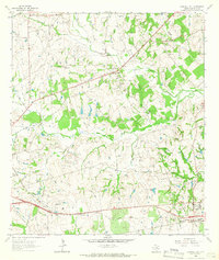
1963 Map of Chappell Hill
USGS Topo · Published 1966About this map
The community of Chappell Hill and the surrounding Washington County landscape are defined by a dense network of family cemeteries and rural institutions in the early 1960s. This survey details a transition from the historic Old Railroad Grade to active lines of the Southern Pacific, alongside educational landmarks like Petersville Sch and Hogans High Sch. The presence of the Zion American Bible College and numerous churches such as Providence Ch and Harris Spring Ch suggests a deeply rooted social fabric centered on small rural settlements like Wiedeville and Earlywine.
Find a feature on this map
42 named features on this map. Tap any name to fly to it.
Don’t see what you’re looking for? This feature index may not catch every label — zoom into the map to look around manually.
Map Details
Editions of this 1963 Chappell Hill Map
2 editions found
Other maps of this area

1914 · Gay Hill
USGS Topo · 1:62,500

1914 · Navasota
USGS Topo · 1:62,500

1930 · Brenham
USGS Topo · 1:62,500

1954 · Austin
USGS Topo · 1:250,000

1956 · Hempstead
USGS Topo · 1:62,500

1956 · Brenham
USGS Topo · 1:62,500

1958 · Washington
USGS Topo · 1:24,000

1959 · Gay Hill
USGS Topo · 1:24,000

1959 · Independence
USGS Topo · 1:24,000
1961 · Daniels
USGS Topo · 1:24,000