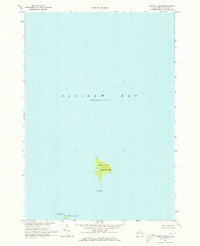
1970 Map of Charity Island
USGS Topo · Published 1973About this map
Charity Island and its smaller neighbors rise out of the shallow depths of Saginaw Bay in this 1970 snapshot of Arenac County’s maritime landscape. The island, which is part of Whitney Twp, is the largest landmass in the bay and shows evidence of past human occupation with the presence of Ruins at its northern tip. South of the main island, the land transitions into Gull Island and Little Charity Island, the latter falling within the boundaries of Sims Twp.
Find a feature on this map
8 named features on this map. Tap any name to fly to it.
Don’t see what you’re looking for? This feature index may not catch every label — zoom into the map to look around manually.
Map Details
Editions of this 1970 Charity Island Map
This is the sole edition of this map. No revisions or reprints were ever made.
Other maps of this area

1954 · Flint
USGS Topo · 1:250,000

1954 · Tawas City
USGS Topo · 1:250,000

1958 · Flint
USGS Topo · 1:250,000

1958 · Tawas City
USGS Topo · 1:250,000

1966 · Point Lookout
USGS Topo · 1:24,000

1966 · Alabaster
USGS Topo · 1:24,000

1970 · Caseville
USGS Topo · 1:24,000

1970 · Sand Point
USGS Topo · 1:24,000

1984 · Tawas City
USGS Topo · 1:100,000
1984 · Bay City
USGS Topo · 1:100,000