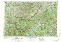
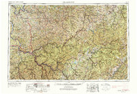
1957 Map of Charleston
USGS Topo · Published 1974About this map
The State Capitol anchors the confluence of the Kanawha River and Elk River, serving as the urban heart of a landscape defined by the winding river valleys of the West Virginia coalfields and the western slopes of the Allegheny Mountains. This mid-century survey documents the transition from rail-dominated transport to the growing highway network, showing Interstate 64 and Interstate 77 carving through the plateau. In the eastern reaches, the dense topography of the Monongahela National Forest rises toward Spruce Knob, where the high-altitude headwaters of the Williams River and Gauley River begin their descent.
Find a feature on this map
131 named features on this map. Tap any name to fly to it.
Don’t see what you’re looking for? This feature index may not catch every label — zoom into the map to look around manually.
Map Details
Editions of this 1957 Charleston Map
3 editions found

Other maps of this area

1886 · St. George
USGS Topo · 1:125,000

1887 · Warfield
USGS Topo · 1:125,000

1887 · Hinton
USGS Topo · 1:125,000

1887 · Lewisburg
USGS Topo · 1:125,000

1889 · Nicholas
USGS Topo · 1:125,000

1889 · Beverly
USGS Topo · 1:125,000

1891 · Lewisburg
USGS Topo · 1:125,000

1891 · Nicholas
USGS Topo · 1:125,000

1891 · Huntersville
USGS Topo · 1:125,000

1891 · Oceana
USGS Topo · 1:125,000