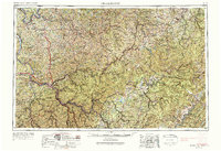
1957 Map of Charleston
USGS Topo · Published 1988About this map
Industrial and capital hubs center on the Kanawha River in this mid-century portrait of central West Virginia. From Charleston and South Charleston through Dunbar and Nitro, the map illustrates a dense corridor of river-fronting settlements supported by the Chesapeake & Ohio RR and New York Central RR. The landscape transitions from these developed valleys into the ridges of the Allegheny Mountains to the east, where the Monongahela National Forest covers vast tracts of timberland. The presence of major reservoirs like Summersville Lake and Sutton Lake reflects the era's focus on flood control and water management. Further west, the Ohio River marks the boundary, while smaller towns like Ripley and Spencer serve as anchors for the rural interior counties. The map effectively captures the intricate relationship between the region's steep topography and its transportation networks, from the winding Elk River to the high peaks of Gauley Mountain.
Find a feature on this map
128 named features on this map. Tap any name to fly to it.
Don’t see what you’re looking for? This feature index may not catch every label — zoom into the map to look around manually.
Map Details
Editions of this 1957 Charleston Map
3 editions found

Other maps of this area

1886 · St. George
USGS Topo · 1:125,000

1887 · Warfield
USGS Topo · 1:125,000

1887 · Hinton
USGS Topo · 1:125,000

1887 · Lewisburg
USGS Topo · 1:125,000

1889 · Nicholas
USGS Topo · 1:125,000

1889 · Beverly
USGS Topo · 1:125,000

1891 · Lewisburg
USGS Topo · 1:125,000

1891 · Nicholas
USGS Topo · 1:125,000

1891 · Huntersville
USGS Topo · 1:125,000

1891 · Oceana
USGS Topo · 1:125,000