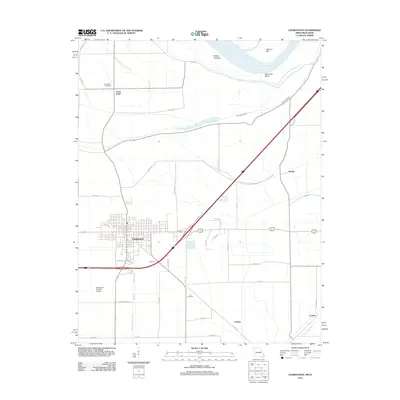
2012 Map of Charleston
USGS Topo · Published 2012About this map
Charleston serves as the central hub of this Mississippi County survey, where the town’s grid meets a network of local roads and interstate infrastructure. The landscape reflects a deeply managed delta environment, characterized by drainage features like Wolf Hole Lateral and Fish Lake Ditch that reclaim the low-lying terrain for agriculture. To the north and east, the Mississippi River creates a dynamic boundary, shaping landmarks such as Dog Tooth Bend, Sliding Towhead, and Browns Bar. Rural life is anchored by small outposts and historical markers including Texas Bend and its namesake Texas Bend Cemetery. The presence of the McDowell-Schmid Airport and settlements like Crenshaw and Hough illustrate the balance between modern transit and the region's enduring agrarian roots along the Big Lake Bayou.
Find a feature on this map
46 named features on this map. Tap any name to fly to it.
Don’t see what you’re looking for? This feature index may not catch every label — zoom into the map to look around manually.
Map Details
Editions of this 2012 Charleston Map
This is the sole edition of this map. No revisions or reprints were ever made.
Other maps of this area

1931 · Cairo
USGS Topo · 1:62,500

1933 · Cairo
USGS Topo · 1:62,500

1934 · Thebes
USGS Topo · 1:62,500

1939 · Wickliffe
USGS Topo · 1:62,500

1939 · Charleston
USGS Topo · 1:62,500

1939 · Cairo
USGS Topo · 1:62,500

1939 · Thebes
USGS Topo · 1:62,500

1949 · Paducah
USGS Topo · 1:250,000

1950 · Paducah
USGS Topo · 1:250,000

1951 · Wickliffe SW
USGS Topo · 1:24,000