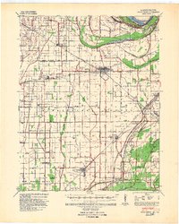
1939 Map of Charleston
USGS Topo · Published 1947About this map
Mississippi River flood control and heavy rail logistics define the landscape of the Bootheel in the late 1930s. Centered on Charleston, the map captures a period when the Missouri Pacific and St Louis Southwestern railroads were the primary arteries for commerce, connecting agricultural hubs like East Prairie and Anniston. The interior is dotted with a high density of rural schoolhouses, including uniquely named landmarks such as Pulltight Sch, Yellow Dog Sch, and Never Spur Sch.
Find a feature on this map
44 named features on this map. Tap any name to fly to it.
Don’t see what you’re looking for? This feature index may not catch every label — zoom into the map to look around manually.
Map Details
Editions of this 1939 Charleston Map
2 editions found
Other maps of this area

1931 · Sikeston
USGS Topo · 1:62,500

1931 · Cairo
USGS Topo · 1:62,500

1933 · Cairo
USGS Topo · 1:62,500

1934 · Thebes
USGS Topo · 1:62,500

1934 · Morley
USGS Topo · 1:62,500

1934 · Sikeston
USGS Topo · 1:62,500

1939 · Wickliffe
USGS Topo · 1:62,500

1939 · Sikeston
USGS Topo · 1:62,500

1939 · Charleston
USGS Topo · 1:62,500

1939 · Hickman
USGS Topo · 1:62,500