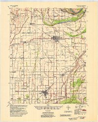
1954 Map of Charleston
USGS Topo · Published 1954About this map
Charleston and East Prairie anchor this 1954 Mississippi River Commission survey, which reveals a landscape defined by an extensive drainage and flood control network. The map detail highlights the massive New Madrid Floodway and a complex system of channels such as Ditch No 10 and Main Ditch, designed to manage the fertile but low-lying bottomlands. These engineering efforts supported a dense network of rural communities, where small settlements like Diehlstadt, Bertrand, and Anniston thrived alongside the Missouri Pacific and St Louis and Southwestern railroads.
Find a feature on this map
60 named features on this map. Tap any name to fly to it.
Don’t see what you’re looking for? This feature index may not catch every label — zoom into the map to look around manually.
Map Details
Editions of this 1954 Charleston Map
2 editions found

Other maps of this area

1931 · Sikeston
USGS Topo · 1:62,500

1931 · Cairo
USGS Topo · 1:62,500

1933 · Cairo
USGS Topo · 1:62,500

1934 · Thebes
USGS Topo · 1:62,500

1934 · Morley
USGS Topo · 1:62,500

1934 · Sikeston
USGS Topo · 1:62,500

1939 · Wickliffe
USGS Topo · 1:62,500

1939 · Sikeston
USGS Topo · 1:62,500

1939 · Charleston
USGS Topo · 1:62,500

1939 · Hickman
USGS Topo · 1:62,500