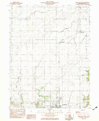
1982 Map of Charleston North
USGS Topo · Published 1983About this map
The agricultural landscape of Seven Hickory and Morgan townships is defined by the rectilinear grid of country roads and drainage systems like District No 3 Drainage. In the early 1980s, these rural stretches were punctuated by small settlements and shipping points such as Fairgrange, situated along the Norfolk and Western line. To the south, the northern edge of Charleston begins to appear, anchored by industrial and communication landmarks including the Radio Towers (WEIC) and the Conrail rail corridor.
Find a feature on this map
23 named features on this map. Tap any name to fly to it.
Don’t see what you’re looking for? This feature index may not catch every label — zoom into the map to look around manually.
Map Details
Editions of this 1982 Charleston North Map
This is the sole edition of this map. No revisions or reprints were ever made.
Other maps of this area

1933 · Toledo
USGS Topo · 1:62,500

1934 · Mattoon
USGS Topo · 1:62,500

1935 · Arcola
USGS Topo · 1:48,000

1936 · Oakland
USGS Topo · 1:48,000

1937 · Mattoon
USGS Topo · 1:62,500

1938 · Toledo
USGS Topo · 1:62,500

1940 · Arcola
USGS Topo · 1:62,500

1942 · Oakland
USGS Topo · 1:62,500

1958 · Decatur
USGS Topo · 1:250,000

1961 · Decatur
USGS Topo · 1:250,000