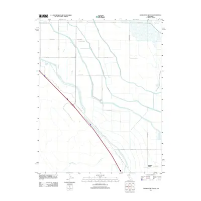
2012 Map of Charleston School
USGS Topo · Published 2012About this map
Large-scale irrigation infrastructure dominates this Merced County landscape, where the Governor Edmund G Brown California Aqueduct and the Delta-Mendota Canal run in parallel across the valley floor. These massive engineering projects, accompanied by the Outside Canal and Gadwall Canal, support a rural agricultural grid defined by long, straight roads such as Almond Dr and Ortigalita Rd. This network serves localized points of activity including Charleston School and the Woo Ranch.
Find a feature on this map
29 named features on this map. Tap any name to fly to it.
Don’t see what you’re looking for? This feature index may not catch every label — zoom into the map to look around manually.
Map Details
Editions of this 2012 Charleston School Map
This is the sole edition of this map. No revisions or reprints were ever made.
Other maps of this area

1913 · Panoche
USGS Topo · 1:125,000

1916 · Delta Ranch
USGS Topo · 1:24,000

1920 · Carrisalito Spring
USGS Topo · 1:31,680

1921 · Volta
USGS Topo · 1:31,680

1921 · Los Banos
USGS Topo · 1:31,680

1921 · Laguna Seca Ranch
USGS Topo · 1:31,680

1922 · Charleston School
USGS Topo · 1:31,680

1922 · Dos Palos
USGS Topo · 1:31,680

1922 · Ortigalita
USGS Topo · 1:31,680
1922 · Delta Ranch
USGS Topo · 1:31,680