
1922 Map of Charleston School
USGS Topo · Published 1922About this map
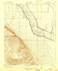
Charleston School stands as a central landmark in this 1919 survey of the Merced County landscape, situated near a burgeoning network of agricultural infrastructure. The territory is defined by the massive San Joaquin and Kings River Canal, which snakes through the eastern half of the sheet, supported by a dense grid of smaller irrigation ditches that signal the region's intensive reclamation for farming. West of the canal, the terrain shifts dramatically from the flat valley floor to the rising foothills, where the seasonal drainage of Ortigalita Creek and Laguna Seca Creek flows down from the higher elevations. This map, published under the direction of George Otis Smith and State Engineer W.F. McClure, illustrates the precise moment when water management began to reshape the Central Valley. Beyond the schoolhouse and the canal, the area is crossed by local routes like Swamp Road, indicating the challenging nature of the low-lying lands before modern drainage.
Find a feature on this map
6 named features on this map. Tap any name to fly to it.
Don’t see what you’re looking for? This feature index may not catch every label — zoom into the map to look around manually.
Map Details
Editions of this 1922 Charleston School Map
2 editions found
Other maps of this area

1913 · Panoche
USGS Topo · 1:125,000

1916 · Delta Ranch
USGS Topo · 1:24,000

1920 · Carrisalito Spring
USGS Topo · 1:31,680

1921 · Volta
USGS Topo · 1:31,680

1921 · Los Banos
USGS Topo · 1:31,680

1921 · Laguna Seca Ranch
USGS Topo · 1:31,680

1922 · Dos Palos
USGS Topo · 1:31,680

1922 · Ortigalita
USGS Topo · 1:31,680
1922 · Delta Ranch
USGS Topo · 1:31,680

1923 · Laguna Seca Ranch
USGS Topo · 1:31,680