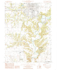
1984 Map of Charleston South
USGS Topo · Published 1985About this map
Eastern Illinois University and the southern extent of Charleston anchor the northern reaches of this mid-1980s landscape, where the urban grid gives way to the deeply incised valleys of the Embarras River. The topography is defined by the contrast between flat upland farmsteads in Pleasant Grove and the intricate drainage networks of Kickapoo Creek and Indian Creek. This survey captures the region's recreational and cultural geography, notably the Fox Ridge State Park and the Lincoln Log Cabin State Historic Site near the southern border.
Find a feature on this map
25 named features on this map. Tap any name to fly to it.
Don’t see what you’re looking for? This feature index may not catch every label — zoom into the map to look around manually.
Map Details
Editions of this 1984 Charleston South Map
This is the sole edition of this map. No revisions or reprints were ever made.
Other maps of this area

1933 · Toledo
USGS Topo · 1:62,500

1934 · Mattoon
USGS Topo · 1:62,500

1935 · Arcola
USGS Topo · 1:48,000

1936 · Oakland
USGS Topo · 1:48,000

1937 · Mattoon
USGS Topo · 1:62,500

1938 · Toledo
USGS Topo · 1:62,500

1940 · Arcola
USGS Topo · 1:62,500

1942 · Oakland
USGS Topo · 1:62,500

1958 · Decatur
USGS Topo · 1:250,000

1961 · Decatur
USGS Topo · 1:250,000