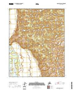
2018 Map of Charley River D-6 NW
USGS Topo · Published 2018About this map
The Public Land Survey System grid provides the primary structure for this 2018 survey of the interior of Alaska. Located in the Yukon-Koyukuk Census Area, this landscape is defined by its lack of established roads or named human settlements, as indicated by the Alaska Dept. of Transportation and GNIS data. The terrain consists of numerous small water bodies and wetlands tracked by the FWS National Wetlands Inventory, scattered among the topographical shifts of township boundaries such as T14n R18e and T13n R19e. The presence of these wetlands alongside numerous unnamed tributaries and ponds suggests a remote and hydrologically complex basin, managed by the BLM and the U.S. Department of the Interior.
Find a feature on this map
6 named features on this map. Tap any name to fly to it.
Don’t see what you’re looking for? This feature index may not catch every label — zoom into the map to look around manually.
Map Details
Editions of this 2018 Charley River D-6 NW Map
This is the sole edition of this map. No revisions or reprints were ever made.
Other maps of this area

1951 · Fort Yukon
USGS Topo · 1:250,000

1951 · Charley River
USGS Topo · 1:250,000

1951 · Black River
USGS Topo · 1:250,000

1951 · Circle
USGS Topo · 1:250,000

1955 · Circle D-1
USGS Topo · 1:63,360

1955 · Circle
USGS Topo · 1:250,000

1956 · Fort Yukon A-1
USGS Topo · 1:63,360

1956 · Black River A-6
USGS Topo · 1:63,360

1956 · Fort Yukon
USGS Topo · 1:250,000

1956 · Black River
USGS Topo · 1:250,000