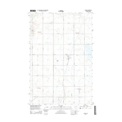
2014 Map of Charlo
USGS Topo · Published 2014About this map
Charlo serves as the central hub of this agricultural landscape in the Mission Valley, defined by a complex irrigation network that supports the surrounding farmsteads. The intricate system of water management is evident through numerous named channels, including the Post Canal, Post 7-D Ditch, and the Post 22-C Lateral, which draw from local sources to transform the prairie. To the east, the Ninepipe Reservoir stands as a significant water body, while the terrain transitions into the Moiese Hills in the northwest corner. Historically significant transport routes such as Old Freight Rd and Dublin Gulch Rd intersect the grid-patterned fields, tracing the legacy of movement through Dublin Gulch. This map provides a clear picture of the modern infrastructure and early 21st-century land use within the Flathead Reservation area, centered on the small-town community of Charlo.
Find a feature on this map
47 named features on this map. Tap any name to fly to it.
Don’t see what you’re looking for? This feature index may not catch every label — zoom into the map to look around manually.
Map Details
Editions of this 2014 Charlo Map
This is the sole edition of this map. No revisions or reprints were ever made.
Other maps of this area

1920 · Flathead Lake
USGS Topo · 1:125,000

1956 · Wallace
USGS Topo · 1:250,000

1960 · Wallace
USGS Topo · 1:250,000

1964 · Dixon
USGS Topo · 1:24,000

1964 · Fort Connah
USGS Topo · 1:24,000

1964 · Ronan
USGS Topo · 1:24,000

1964 · Lower Crow Reservoir
USGS Topo · 1:24,000

1964 · Saint Ignatius
USGS Topo · 1:24,000

1964 · Ravalli
USGS Topo · 1:24,000

1965 · Sloan
USGS Topo · 1:24,000