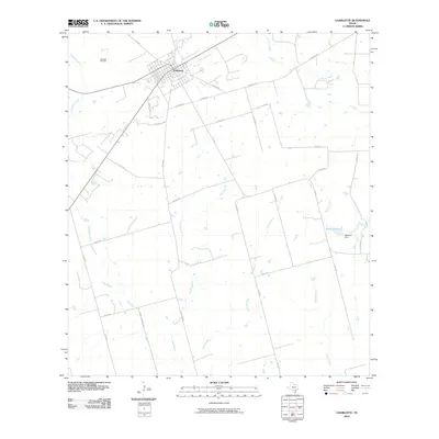
2010 Map of Charlotte
USGS Topo · Published 2010About this map
Charlotte serves as the primary hub in this South Texas landscape, defined by a grid of rural roads and the local energy industry. The presence of the Charlotte Oil Field and the Oil Field Lease near Sierra Lease illustrates the importance of petroleum extraction to the local economy during this era. The terrain is etched by several prominent drainage systems, including Lagunillas Creek, La Parita Creek, and Macho Creek, which dictate the placement of ranch roads and property boundaries. To the east, the Marshall Dam creates Marshall Lake along Turkey Creek, providing a rare permanent water feature in a region characterized by ephemeral branches like Doak Branch and Bear Branch. This network of country roads, such as Burns-Eppright Rd and Bluntzer Rd, connects the outlying ranch lands back to the town center.
Find a feature on this map
32 named features on this map. Tap any name to fly to it.
Don’t see what you’re looking for? This feature index may not catch every label — zoom into the map to look around manually.
Map Details
Editions of this 2010 Charlotte Map
This is the sole edition of this map. No revisions or reprints were ever made.
Other maps of this area

1934 · Schattel
USGS Topo · 1:62,500

1953 · Crystal City
USGS Topo · 1:250,000

1955 · Crystal City
USGS Topo · 1:250,000

1956 · Jourdanton
USGS Topo · 1:62,500

1956 · Hindes
USGS Topo · 1:62,500

1956 · Franklin Settlement
USGS Topo · 1:62,500

1961 · Crystal City
USGS Topo · 1:250,000

1968 · Crystal City
USGS Topo · 1:250,000
1968 · Jourdanton
USGS Topo · 1:24,000
1968 · Dobrowolski
USGS Topo · 1:24,000