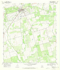
1968 Map of Charlotte
USGS Topo · Published 1971About this map
The town of Charlotte serves as the focal point for this late-1960s survey of southern Texas, situated at the intersection of State Highway 97 and Route 1333. The landscape is defined by the extraction economy of the era, dominated by the expansive Charlotte Oil Field and the neighboring Jourdanton Oil Field to the east. A network of wells and a major Pipeline illustrate the industrial footprint upon the Atascosa County brushland.
Find a feature on this map
19 named features on this map. Tap any name to fly to it.
Don’t see what you’re looking for? This feature index may not catch every label — zoom into the map to look around manually.
Map Details
Editions of this 1968 Charlotte Map
This is the sole edition of this map. No revisions or reprints were ever made.
Other maps of this area

1934 · Schattel
USGS Topo · 1:62,500

1953 · Crystal City
USGS Topo · 1:250,000

1955 · Crystal City
USGS Topo · 1:250,000

1956 · Jourdanton
USGS Topo · 1:62,500

1956 · Hindes
USGS Topo · 1:62,500

1956 · Franklin Settlement
USGS Topo · 1:62,500

1961 · Crystal City
USGS Topo · 1:250,000

1968 · Crystal City
USGS Topo · 1:250,000
1968 · Jourdanton
USGS Topo · 1:24,000
1968 · Dobrowolski
USGS Topo · 1:24,000