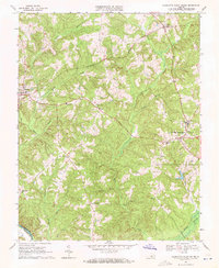
1968 Map of Charlotte Court House
USGS Topo · Published 1971About this map
Charlotte Court House serves as the focal point of this late 1960s survey, showing the historic village layout and nearby educational institutions such as Randolph-Henry Sch. The landscape is defined by the heavy dissection of the Piedmont plateau, where numerous watercourses like Wards Fork Creek and Cub Creek drain toward the Roanoke River at the southern boundary. This map captures the rural character of Charlotte County before significant modernization, documenting several localized crossroads including Cullen, Phenix, and Fears Corner.
Find a feature on this map
36 named features on this map. Tap any name to fly to it.
Don’t see what you’re looking for? This feature index may not catch every label — zoom into the map to look around manually.
Map Details
Editions of this 1968 Charlotte Court House Map
3 editions found
Other maps of this area

1892 · Appomattox
USGS Topo · 1:125,000

1947 · Roanoke
USGS Topo · 1:250,000

1953 · Greensboro
USGS Topo · 1:250,000

1954 · Greensboro
USGS Topo · 1:250,000

1954 · Clover
USGS Topo · 1:62,500

1954 · Halifax
USGS Topo · 1:62,500

1956 · Brookneal
USGS Topo · 1:62,500

1956 · Charlotte Court House
USGS Topo · 1:62,500

1959 · Roanoke
USGS Topo · 1:250,000

1962 · Greensboro
USGS Topo · 1:250,000