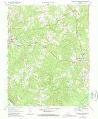
1968 Map of Charlotte Court House
USGS Topo · Published 1987About this map
Charlotte Court House serves as the focal point for this Virginia landscape, where the rural topography is defined by the headwaters of the Roanoke River. The settlement pattern in the late 1960s reflects a community structured around civic life and education, anchored by institutions like the Randolph-Henry Sch and Central High Sch. In the western portion of the sheet, the village of Phenix sits along the Norfolk and Western railroad, marked by the nearby Phenix Lookout Tower and Jeffress Memorial Sch.
Find a feature on this map
35 named features on this map. Tap any name to fly to it.
Don’t see what you’re looking for? This feature index may not catch every label — zoom into the map to look around manually.
Map Details
Editions of this 1968 Charlotte Court House Map
3 editions found
Other maps of this area

1892 · Appomattox
USGS Topo · 1:125,000

1947 · Roanoke
USGS Topo · 1:250,000

1953 · Greensboro
USGS Topo · 1:250,000

1954 · Greensboro
USGS Topo · 1:250,000

1954 · Clover
USGS Topo · 1:62,500

1954 · Halifax
USGS Topo · 1:62,500

1956 · Brookneal
USGS Topo · 1:62,500

1956 · Charlotte Court House
USGS Topo · 1:62,500

1959 · Roanoke
USGS Topo · 1:250,000

1962 · Greensboro
USGS Topo · 1:250,000