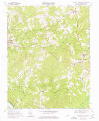
1968 Map of Charlotte Court House
USGS Topo · Published 1977About this map
The county seat at Charlotte Court House serves as the focal point of this late 1960s landscape, where a dense network of local schools and churches reflects the established community structure of south-central Virginia. Educational landmarks such as Randolph-Henry Sch and Central High Sch appear alongside rural community hubs like Jeffress Memorial Sch. The Norfolk and Western railroad corridor passes through the northern reaches, connecting the settlements of Phenix and Cullen through a terrain defined by the winding tributaries of Roanoke Creek. The map documents numerous smaller crossroads like Chandlers Forks, Fears Corner, and Harrisburg, each situated among the complex drainage patterns of Wards Fork and Sandy Creek. These family-named junctions and small rural congregations, including Mt Tirzah Ch and Village Ch, provide a detailed look at the social geography before significant modern modernization occurred.
Find a feature on this map
38 named features on this map. Tap any name to fly to it.
Don’t see what you’re looking for? This feature index may not catch every label — zoom into the map to look around manually.
Map Details
Editions of this 1968 Charlotte Court House Map
3 editions found
Other maps of this area

1892 · Appomattox
USGS Topo · 1:125,000

1947 · Roanoke
USGS Topo · 1:250,000

1953 · Greensboro
USGS Topo · 1:250,000

1954 · Greensboro
USGS Topo · 1:250,000

1954 · Clover
USGS Topo · 1:62,500

1954 · Halifax
USGS Topo · 1:62,500

1956 · Brookneal
USGS Topo · 1:62,500

1956 · Charlotte Court House
USGS Topo · 1:62,500

1959 · Roanoke
USGS Topo · 1:250,000

1962 · Greensboro
USGS Topo · 1:250,000