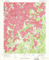
1967 Map of Charlotte East
USGS Topo · Published 1969About this map
Charlotte is captured during a period of significant urban expansion, where dense metropolitan grids push into the surrounding countryside of Mecklenburg County. The landscape is defined by the convergence of the Southern Railway and the Seaboard Coast Line Railroad, which historically anchored the city's industrial and commercial core. Educational and social institutions are prominent, ranging from Johnson Smith University and Queens College to the Thompson Orphanage, reflecting the city's role as a regional hub for learning and community welfare.
Find a feature on this map
104 named features on this map. Tap any name to fly to it.
Don’t see what you’re looking for? This feature index may not catch every label — zoom into the map to look around manually.
Map Details
Editions of this 1967 Charlotte East Map
3 editions found
Other maps of this area

1905 · Charlotte
USGS Topo · 1:48,000

1907 · Charlotte
USGS Topo · 1:62,500

1941 · Charlotte
USGS Topo · 1:125,000

1942 · Charlotte
USGS Topo · 1:125,000

1948 · Paw Creek
USGS Topo · 1:24,000

1948 · Derita
USGS Topo · 1:24,000

1948 · Charlotte East
USGS Topo · 1:24,000

1948 · Charlotte West
USGS Topo · 1:24,000

1949 · Charlotte West
USGS Topo · 1:24,000

1949 · Charlotte East
USGS Topo · 1:24,000
Featured Places
- Charlotte, NC
- Beverly Woods East, Charlotte
- Carmel Woods, Charlotte
- Olde Heritage, Charlotte
- Spring Valley, Charlotte