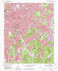
1967 Map of Charlotte East
USGS Topo · Published 1981About this map
Charlotte is shown at a pivotal moment of mid-century urban expansion, where dense historical neighborhoods meet the rising outward growth of the 1960s and 70s. The map illustrates the convergence of the Southern and Seaboard Coast Line railroads at the city center, a network that anchored the textile and distribution economy for decades. Significant community landmarks, from the Thompson Orphanage to the Johnson C Smith University campus, are surrounded by a landscape increasingly defined by highway corridors and public institutions like Central Piedmont Community College. Purple photogrammetric revisions highlight the rapid transformation of the suburbs, particularly in the southeastern areas near Rama. Numerous schools and cemeteries, including the Hebrew Cem and Evergreen Cemetery, provide precise geographic anchors for genealogists and local historians tracking the shifting footprints of this North Carolina hub.
Find a feature on this map
94 named features on this map. Tap any name to fly to it.
Don’t see what you’re looking for? This feature index may not catch every label — zoom into the map to look around manually.
Map Details
Editions of this 1967 Charlotte East Map
3 editions found
Other maps of this area

1905 · Charlotte
USGS Topo · 1:48,000

1907 · Charlotte
USGS Topo · 1:62,500

1941 · Charlotte
USGS Topo · 1:125,000

1942 · Charlotte
USGS Topo · 1:125,000

1948 · Paw Creek
USGS Topo · 1:24,000

1948 · Derita
USGS Topo · 1:24,000

1948 · Charlotte East
USGS Topo · 1:24,000

1948 · Charlotte West
USGS Topo · 1:24,000

1949 · Charlotte West
USGS Topo · 1:24,000

1949 · Charlotte East
USGS Topo · 1:24,000
Featured Places
- Charlotte, NC
- Beverly Woods East, Charlotte
- Carmel Woods, Charlotte
- Olde Heritage, Charlotte
- Spring Valley, Charlotte