1905 Map of Charlotte
USGS Topo · Published 1960About this map
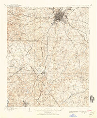
The growing town of Charlotte serves as the hub for this 1905 landscape, appearing before the major suburban sprawl that would define the mid-century. Early educational landmarks such as Biddle College and Elizabeth College flank the town center, while established neighborhoods like Dilworth and Piedmont suggest the initial phases of urban expansion. Beyond the city limits, the landscape transitions into agricultural townships like Sharon, Providence, and Berryhill, where social life centered around a dense network of country churches, including Steel Creek Church, McClintock Church, and Philadelphia Church.
Find a feature on this map
89 named features on this map. Tap any name to fly to it.
Don’t see what you’re looking for? This feature index may not catch every label — zoom into the map to look around manually.
Map Details
Editions of this 1905 Charlotte Map
2 editions found
Other maps of this area

1905 · Charlotte
USGS Topo · 1:48,000

1907 · Charlotte
USGS Topo · 1:62,500

1914 · Gastonia
USGS Topo · 1:48,000

1916 · Gastonia
USGS Topo · 1:62,500

1941 · Charlotte
USGS Topo · 1:125,000

1941 · Spartanburg
USGS Topo · 1:250,000

1942 · Charlotte
USGS Topo · 1:125,000

1947 · Clover
USGS Topo · 1:62,500

1948 · Paw Creek
USGS Topo · 1:24,000

1948 · Derita
USGS Topo · 1:24,000