1942 Map of Charlotte
USGS Topo · Published 1942About this map
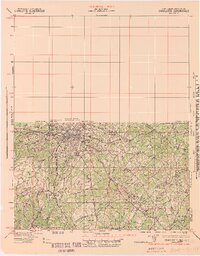
Charlotte is shown at a pivotal moment in the early 1940s, revealing a dense rail-and-creek landscape just as the region prepared for wartime industrial expansion. The city center radiates outward toward neighborhoods like Meyers Park and Chadwick Hoskins, supported by a robust network of the Southern, Seaboard Air Line, and Norfolk Southern railroads. Beyond the urban core, the map detail focuses on the rural-to-suburban transition, where family-named landmarks like Alexanders Store and community hubs like Wesley Chapel provided social structure for the farming districts of Mecklenburg and Union counties. The drainage patterns of Sugar Creek and McAlpine Creek dominate the southern terrain, weaving through small hubs such as Pineville and Matthews before crossing the state line.
Find a feature on this map
46 named features on this map. Tap any name to fly to it.
Don’t see what you’re looking for? This feature index may not catch every label — zoom into the map to look around manually.
Map Details
Editions of this 1942 Charlotte Map
2 editions found
Other maps of this area

1893 · Statesville
USGS Topo · 1:125,000

1895 · Hickory
USGS Topo · 1:125,000

1905 · Charlotte
USGS Topo · 1:48,000

1907 · Charlotte
USGS Topo · 1:62,500

1914 · Gastonia
USGS Topo · 1:48,000

1916 · Gastonia
USGS Topo · 1:62,500

1941 · Charlotte
USGS Topo · 1:125,000

1941 · Spartanburg
USGS Topo · 1:250,000

1942 · Charlotte
USGS Topo · 1:125,000

1947 · Clover
USGS Topo · 1:62,500