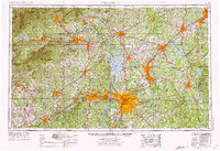
1953 Map of Charlotte
USGS Topo · Published 1975About this map
The Catawba River and its massive impoundments anchor this mid-century portrait of the North Carolina Piedmont, showing the region as its modern industrial and transit identity solidified. Large-scale reservoirs like Lake Norman and High Rock Lake dominate the central corridor, while the urban centers of Charlotte, Gastonia, and Salisbury are shown at a pivotal moment of expansion. The map details the complex transportation network that fueled this growth, including the Southern Railway and the Piedmont and Northern Railway, alongside the emerging interstate highway system.
Find a feature on this map
262 named features on this map. Tap any name to fly to it.
Don’t see what you’re looking for? This feature index may not catch every label — zoom into the map to look around manually.
Map Details
Editions of this 1953 Charlotte Map
3 editions found

Other maps of this area

1889 · Wilkesboro
USGS Topo · 1:125,000

1891 · Roan Mountain
USGS Topo · 1:125,000

1891 · Wilkesboro
USGS Topo · 1:125,000

1891 · Yadkinville
USGS Topo · 1:125,000

1893 · Cranberry
USGS Topo · 1:125,000

1893 · Statesville
USGS Topo · 1:125,000

1893 · Yadkinville
USGS Topo · 1:125,000

1894 · Roan Mountain
USGS Topo · 1:125,000

1895 · Hickory
USGS Topo · 1:125,000

1895 · Cranberry
USGS Topo · 1:125,000